


Houthis Seek Space-Based Surveillance Over Bab al-Mandab, Threatening Shipping
|
9 hours ago
A-
A+
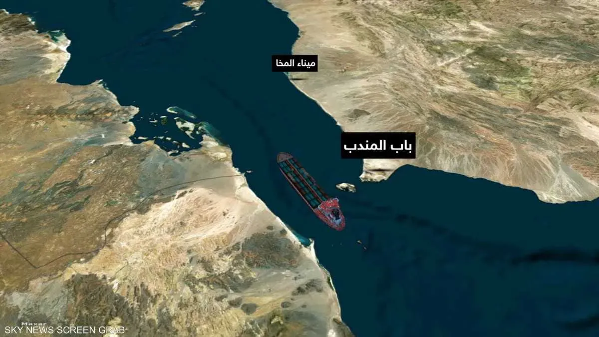
Intelligence sources indicate that the Houthi external intelligence service, backed by Iran, has entered into new agreements with a Chinese company to acquire satellite imagery and maritime surveillance data. This move reportedly aims to enhance the militia's ability to track vessel movements, including those of Saudi and allied warships in the Red Sea, Gulf of Aden, and Arabian Sea. These developments coincide with the Houthi militia's expanding influence along Yemen's western coast, reaching strategically vital areas near the Bab al-Mandab strait and Perim Island. If confirmed, this expansion could grant the militia greater capability to integrate ground control with maritime surveillance. The intelligence sought reportedly extends beyond military vessels to include commercial and Western shipping, as well as locations in countries hosting forces or facilities associated with the U.S. Fifth Fleet. These efforts, if verified, raise concerns that the Houthi threat, previously focused on missile and drone attacks, could evolve into a broader intelligence-gathering system monitoring traffic and military assets in a critical global maritime corridor. According to sources, the alleged agreements include satellite images, geographical, and intelligence data usable for planning missile and drone operations. This information may encompass target locations, movements, and speeds, including "real-time coordinates." The data is reportedly being transferred via encrypted satellite communication and internet links to Houthi operations rooms in Sana'a and Hodeidah, with Iranian surveillance ships in the region acting as intermediaries. Sources also mentioned the provision of electronic components for guidance systems, though "Sheba Intelligence" could not independently verify these claims or the extent to which the agreements have been implemented, nor the alleged communication arrangements or the role of Iranian vessels. If these arrangements are confirmed, the regular provision of maritime reconnaissance data could significantly improve the Houthi militia's ability to identify targets and time attacks, thereby increasing the challenges for protecting military and commercial vessels transiting the area. The Chinese company identified is "Mynteropy Technology" based in Hangzhou, also operating as "MizarVision." The agreements were allegedly brokered through the Iranian military attaché's office in China, which connected the company with Houthi liaison officers residing in Muscat. Mynteropy Technology (Hangzhou) Co., Ltd. was listed on U.S. sanctions by the Treasury Department in May 2026 in connection with Iran. MizarVision publicly describes itself as a geospatial intelligence platform utilizing AI for image and location data analysis. This public description does not confirm the sources' claims regarding the provision of military components or guidance systems for missiles and drones. The Houthi pursuit of space-based reconnaissance capabilities is not entirely new; a previous report by "Sheba Intelligence" in June indicated similar efforts to acquire Chinese satellite imagery and related capabilities through channels linked to the Iranian Embassy in Muscat. The significance of these efforts is amplified by the strategic location of Yemen's western coast and the Bab al-Mandab strait, a crucial link between the Red Sea, the Gulf of Aden, and the Indian Ocean. Advanced maritime information gathering and analysis capabilities could introduce a new dimension to regional security risks, potentially enabling the Houthi militia to monitor a wider range of vessel traffic and enhance target selection. The implications extend beyond Yemen, as the Bab al-Mandab is vital for international trade. Any increased capability by an armed group to monitor or threaten shipping could impact maritime security, supply chains, and shipping costs globally. Furthermore, targeting commercial or military vessels based on more precise intelligence could compel international shipping companies and navies to implement additional protective measures, including rerouting and enhanced surveillance. For Yemen, the potential transformation of coastal areas near Bab al-Mandab into intelligence-gathering platforms threatens to escalate the region into a broader conflict zone, increasing the risks of retaliatory strikes and counter-operations, with potential consequences for local populations, infrastructure, and ports. However, possessing satellite imagery does not automatically translate to immediate, continuous monitoring of every vessel at sea. Traditional satellite imagery relies on orbital passes, and data processing and transmission take time. While radar satellites can operate at night and in adverse weather, their military effectiveness depends on imaging frequency, processing speed, communication, and analysis capabilities. Space-based reconnaissance data differs from GPS, which only provides location and timing for the receiver. The Houthi militia's ability to convert satellite data into actionable military intelligence depends on an integrated system of reconnaissance, communication, analysis, and guidance, not solely on satellite images. Nevertheless, if the Houthi militia, supported by Iran, consistently obtains such data and integrates it with their missile and drone capabilities, it could represent a significant advancement in their maritime reconnaissance capacity, thereby escalating the risks to navigation in the Bab al-Mandab, Red Sea, and Gulf of Aden. "Sheba Intelligence" has not been able to independently verify the alleged agreements, the commencement of services, or all the communication arrangements and guidance component supplies mentioned by the sources. |